
Saturday, December 24, 2011
Monday, December 19, 2011
Art Is Good Day
So...'R' and I headed on down to the UU Church to pick up the craft stuff that I had set up for their Christmas Sale. Not my usual venue (that being the PTO sale that I kinda boycotted this year) and I wasn't hopeful for much interest in my hand-painted ivory jewelry or miniatures on easels. The sale ran for three Saturdays and all I had to do was set up a small table and provide an inventory of my items. Well....a superb Christmas surprise awaited me this morning. Yep, stuff sold. I totaled as much in sales as if I had participated in the PTO sale and spent the day sitting there minding the table! I'm real happy. Sign me up for next year!
Another Monday bonus was waiting just for me (not really, could have been for anyone), at the supermarket. We need a larger bin for hats, scarfs, gloves and mittens now that our household is larger. I found a slightly overpriced woven bin on the top shelf near the laundry detergents. So I thought oh well, we need it so I'll pay a bit too much to get it. We headed through the checkout with the bin as a separate item from the groceries that 'R' was getting. Lo and behold it rang up as higher priced than the tag said it should be! Ahemmmm....excuse me 'M', who was cashiering. 'M' called the manager over and guess what? Store policy - pricing error and you get the item free!
Yay! Yippeeeeeeee!
And finally, a new painting has been added to the collection.
The remains of the Cape Ann Tool Company as seen from Pigeon Cove, Rockport.

Sunday, December 18, 2011
When It's Cold Outside

Tequila Christmas Cake
*Ingredience:*
1 cup sugar
1 tsp. baking powder
1 cup water
1 tsp. salt
1 cup brown sugar
Lemon juice
4 large eggs
Nuts
1 bottle tequila
2 cups dried fruit
*Directions:*
Sample the tequila to check quality.
Take a large bowl; check the tequila again to be sure it is of the highest quality.
Repeat.
Turn on the electric mixer.
Beat one cup of butter in a large fluffy bowl.
Add 1 teaspoon of sugar.
Beat again.
At this point, it is best to make sure the tequila is still OK.
Try another cup just in case.
Turn off the mixerer thingy.
Break 2 eegs and add to the bowl and chuck in the cup of dried fruit.
Pick the fruit up off the floor.
Mix on the turner. If the fried druit getas stuck in the beaterers, just
pry it loose with a drewscriver.
Sample the tequila to test for tonsisticity.
Next, sift 2 cups of salt, or something.
Check the tequila.
Now shift the lemon ice strain your nuts.
Add one table.
Add a spoon of sugar, or somefink. Whatever you can find.
Greash the oven.
Turn the cake tin 360 degrees and try not to fall over.
Don't forget to beat off the turner.
Finally, throw the bowl through the window.
Finish the tequila and wipe the counter with the cat.
(Thanks to Joe G.)
Monday, December 12, 2011
Cat Lovers in Dogtown - Trip Four
I decided that trip four In should start at the top of Gee Avenue in Gloucester. This would lead us to Commons Road, the northern main road of Dogtown. It was an easy, paved...yes, paved!...curve around the Goose Cove reservoir which upon its creation had left part of Commons Road submerged. We picked up the old Commons Road...unpaved...exactly opposite this spot:
Our first hike was to find Peter's Pulpit. Supposedly an enormous erratic the size of 20 automobiles. Yep, it was big, but not very impressive. I guess I felt that a 'pulpit' would indicate something much more vertical than horizontal. Oh well. Slightly disappointed but there were still other things to find.
We hiked a crossroad called Wharf Road over to the southern side of Dogtown in hopes of finding a couple more of the Babson Boulders.
Wharf Road is named such, not because of a wharf for boating or fishing, but after the man who lived along the edge, Abram Wharf. Where Wharf Road meets up with Dogtown Road, there were a couple spots where we could see Granny Day's Swamp. Sheep and cows often got stuck in the mire of Granny Day's Swamp!
We found two more inscribed boulders:
After taking some photos we headed back the way we had come In with only one variation. We have been deciphering conflicting maps and have discovered one that shows numbered intersections. This helps a lot and saved us some retracing of footsteps by taking a different fork where Wharf Road meets Commons Road.
Our last stop of the trip was to photograph the boulder below, held from rolling down a steep embankment by one struggling tree!
The Commons Road hike was the longest that we have done. Not much happening along it and we most likely will not use it for an entrance In again. Upon returning home, I found that we are still missing 4 Babson Boulders in our collection. Two are at the railroad end of the Babson Trail. The other two, upon some research, appear to be in the same area as we were on this trip! Must do some more hunting. From the Dogtown Road side next time. 'R' is being very tolerant of my desire to explore Dogtown!
 |
| Goose Cove Reservoir |
Our first hike was to find Peter's Pulpit. Supposedly an enormous erratic the size of 20 automobiles. Yep, it was big, but not very impressive. I guess I felt that a 'pulpit' would indicate something much more vertical than horizontal. Oh well. Slightly disappointed but there were still other things to find.
 |
| Peter's Pulpit |
We hiked a crossroad called Wharf Road over to the southern side of Dogtown in hopes of finding a couple more of the Babson Boulders.
 |
| Wharf Road (Dogtown's Roads challenge footing!) |
Wharf Road is named such, not because of a wharf for boating or fishing, but after the man who lived along the edge, Abram Wharf. Where Wharf Road meets up with Dogtown Road, there were a couple spots where we could see Granny Day's Swamp. Sheep and cows often got stuck in the mire of Granny Day's Swamp!
 |
| A peek at Granny Day's Swamp |
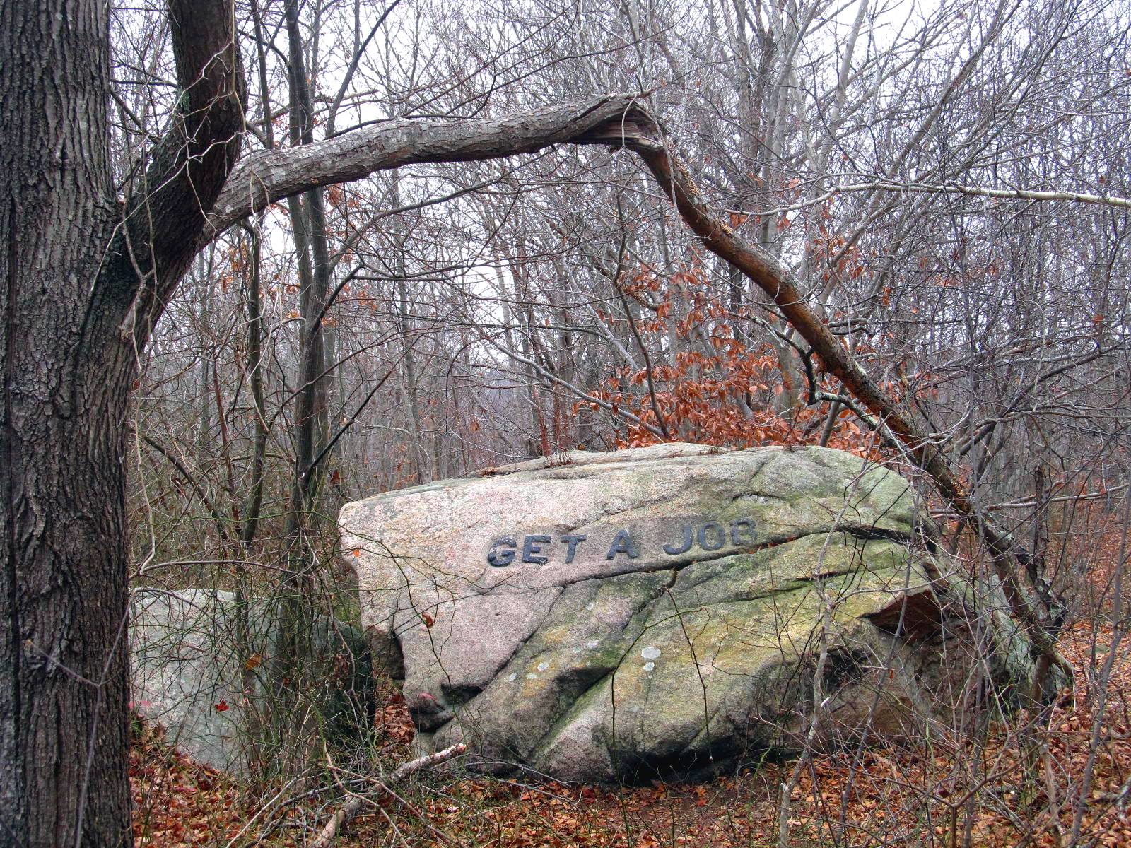
We found two more inscribed boulders:
 |
| Keep Out Of Debt |
 |
| If Work Stops Values Decay |
After taking some photos we headed back the way we had come In with only one variation. We have been deciphering conflicting maps and have discovered one that shows numbered intersections. This helps a lot and saved us some retracing of footsteps by taking a different fork where Wharf Road meets Commons Road.
 |
| Intersection 4 (this one painted on a rock, some are painted on trees) |
Our last stop of the trip was to photograph the boulder below, held from rolling down a steep embankment by one struggling tree!
 |
| propped on the edge |
The Commons Road hike was the longest that we have done. Not much happening along it and we most likely will not use it for an entrance In again. Upon returning home, I found that we are still missing 4 Babson Boulders in our collection. Two are at the railroad end of the Babson Trail. The other two, upon some research, appear to be in the same area as we were on this trip! Must do some more hunting. From the Dogtown Road side next time. 'R' is being very tolerant of my desire to explore Dogtown!
Saturday, December 10, 2011
Cat Lovers in Dogtown - Trip Three
I thought before tomorrow and trip four rolled around I'd best relate a little about trip three.
This time we decided to try going In from the Gloucester side of Dogtown. Much easier with a relatively smooth access road! We passed several numbered stones that designated sites of cellar holes - the only remains of homes in Dogtown.
A bit further along and we were 'told' that we had arrived at Dogtown Square. Wow, things must have changed a lot being as other than the sign there was no indication whatsoever that a town square ever existed.
We took a right turn and wandered slightly uphill to the commons, a relatively open area where the sheep and cattle of all the settlement would have grazed. We passed some other numbered stones and, not seeing any cellar holes, didn't investigate. If we had, we would have found a couple more Babson Boulders. Oh well, we'll visit them tomorrow on Trip Four.
We did find 14 on this trip and I'll show a couple examples...don't worry won't post all the pics! And the question of count will be answered with these two 'pages' of Babson's book.
 Two sides of the same boulder have been carved.

While we were walking up toward the common pasture, we met a woman walking out. As is custom in our small community, we said hello. She greeted us and told us that there was a large pack of dogs up ahead. Probably 15 or so, she said. Hmmmm. Then she added that they were friendly. Double hmmmm. I think she was trying to spook us. Didn't work. (Never saw or heard any dogs) As a matter of fact, we haven't seen any wildlife at all in Dogtown. No birds, no squirrels, nothing.

We doubled back from the commons pasture and took a side trip down the Babson Boulder Trail. It was rough walking and a large portion was up and down hills. We decided that when it reach 11:30 we would turn around and head back toward the car. On the boulder trail we found the rest of our 14 count for the trip. 2 more are further along the trail and we'll grab shots of them another time.

Tomorrow we plan on making our fourth trip In. Maybe starting at the top of Squam Road once again and follow the trail past Whale's Jaw to Peter's Pulpit (it's supposed to be a mammoth erratic) and then on to the Commons Road before turning around and heading home.
This time we decided to try going In from the Gloucester side of Dogtown. Much easier with a relatively smooth access road! We passed several numbered stones that designated sites of cellar holes - the only remains of homes in Dogtown.
 |
| Number 20 marks the site of Granny Day's home |
 |
| A cellar hole marked by stone carving 17 |
A bit further along and we were 'told' that we had arrived at Dogtown Square. Wow, things must have changed a lot being as other than the sign there was no indication whatsoever that a town square ever existed.
 |
| We arrived at Dogtown Square! |
We took a right turn and wandered slightly uphill to the commons, a relatively open area where the sheep and cattle of all the settlement would have grazed. We passed some other numbered stones and, not seeing any cellar holes, didn't investigate. If we had, we would have found a couple more Babson Boulders. Oh well, we'll visit them tomorrow on Trip Four.
We did find 14 on this trip and I'll show a couple examples...don't worry won't post all the pics! And the question of count will be answered with these two 'pages' of Babson's book.


While we were walking up toward the common pasture, we met a woman walking out. As is custom in our small community, we said hello. She greeted us and told us that there was a large pack of dogs up ahead. Probably 15 or so, she said. Hmmmm. Then she added that they were friendly. Double hmmmm. I think she was trying to spook us. Didn't work. (Never saw or heard any dogs) As a matter of fact, we haven't seen any wildlife at all in Dogtown. No birds, no squirrels, nothing.

We doubled back from the commons pasture and took a side trip down the Babson Boulder Trail. It was rough walking and a large portion was up and down hills. We decided that when it reach 11:30 we would turn around and head back toward the car. On the boulder trail we found the rest of our 14 count for the trip. 2 more are further along the trail and we'll grab shots of them another time.

Tomorrow we plan on making our fourth trip In. Maybe starting at the top of Squam Road once again and follow the trail past Whale's Jaw to Peter's Pulpit (it's supposed to be a mammoth erratic) and then on to the Commons Road before turning around and heading home.
Monday, December 05, 2011
Cat Lovers in Dogtown - Trips One and Two
I have been trying to take Sunday off each week. If I stay home I do tend to wander down to the workshop and...well...work. This means we must head off, away from the house so I can't work.
'R' and I have decided that our get away from home destination shall be exploring Dogtown.
In 1741, 20% of Gloucester's population lived in what was then known as the Commons Settlement. This area covers the majority of the center of our island and was primarily a farming and forestry based economy. The fishing industry which eventually grew to be the main industry of the island was at that time nearly non-existent due to great losses to piracy. The Commons Settlement was also the hub of the island with roads connecting Gloucester to Lanesville to Annisquam to Rockport. Sixty of the most prominent island families called the Commons Settlement home. It was the most desirable part of town.
The men of the Commons Settlement participated heavily in the Revolutionary War and at the end few remained to return to their homes on the island. Their widows were left to try to eke out an existence on land that had been stripped of all the wood. Many subsisted on the abundant berries found and killed their animals for the last remaining meals of meat. Whether for company or for protection, the women left at the Commons Settlement kept dogs. That, combined with the rapid decay of the area, seems to be why the Commons Settlement, once a thriving, desirable community became known as Dogtown.
With the end of the war and control gained over the local waters, the fishing industry grew. Prominent families wanted to live in new, elegant homes at the harbor. New roads were built that, in staying along the water, bypassed Dogtown.
In 1830, suffering from frozen feet, the last resident was removed from the cellar of a home and placed in the Poor House where he died within a few days. By 1841, there were only six of the original 80 houses left in Dogtown. In 1845 the last house was torn down. Dogtown was an embarrassment.
The land was left vacant. Eventually Roger Babson purchased a large portion with the intent of keeping open space on the island. In the years that followed, he not only donated a large portion to the city for a reservoir, he also hired out of work quarrymen to 'write' a book of morals by carving words in some of the large boulders of Dogtown. The acreage of Dogtown is a vast expanse of terminal moraine. Large granite boulders called erratics are strewn about the area and acres are covered in piles of granite 'rubble' left behind when the last great ice flow receded.
Present day Dogtown is filled with a maze of trails running between the old Dogtown Road, the Commons Road, and the Old Rockport Road (don't let the word road fool you...they aren't paved!). Along the trails are markers indicating the 'cellar holes' and other bits of interesting things like Granny Day's Swamp. The casual hiker can easily get lost and 'R' and I were sure to bring several maps (even if they were a bit conflicting between themselves) and a cell phone. We decided to explore with a definite plan and to keep track of the time at certain locations. We always mark any turns taken from the main trail. We are determined NOT to dial 911 as a tourist did recently!
Our first venture In was from Old Rockport Road. Not much to be seen along there! It would have been far more productive to have entered from near Blackburn Circle (Blackburn Industrial Park) where it would have been a short wooded walk to see: The Babson Boulders!

and

and
 Not mentioned on the map, but quickly spotted were:


Our first five Babson Boulders. Only 19 left to find!
At that point it was getting chilly and foggy (and darn close to lunch time) so we headed back by the same route as we went in. We decided to try a different hike in the afternoon.
Our afternoon hike was to Whale's Jaw. Whale's Jaw used to resemble it's name much more than it does now. Not long ago the 'jaw' portion split off and fell. Some claim it was due to a fire being set beneath it. I find it rather hard to believe that a smallish fire would break such a large boulder (about 18 - 20 feet at the tallest point). My thinking leans more towards the hundreds of years of water freezing and thawing in the 'jaw' joint.
Since it was getting on toward sunset, it was a quick trip of about 45 minutes.
We'll head out (or In) past Whale's Jaw again soon.
On our third venture to Dogtown we followed Dogtown Road and saw some of the cellar holes. From there we hiked the Boulder Trail and captured fourteen more Babson Boulders. Only six left to find! And for those of you doing the math, that little discrepancy will be explained in Cat Lovers in Dogtown - Trip Three
'R' and I have decided that our get away from home destination shall be exploring Dogtown.
In 1741, 20% of Gloucester's population lived in what was then known as the Commons Settlement. This area covers the majority of the center of our island and was primarily a farming and forestry based economy. The fishing industry which eventually grew to be the main industry of the island was at that time nearly non-existent due to great losses to piracy. The Commons Settlement was also the hub of the island with roads connecting Gloucester to Lanesville to Annisquam to Rockport. Sixty of the most prominent island families called the Commons Settlement home. It was the most desirable part of town.
The men of the Commons Settlement participated heavily in the Revolutionary War and at the end few remained to return to their homes on the island. Their widows were left to try to eke out an existence on land that had been stripped of all the wood. Many subsisted on the abundant berries found and killed their animals for the last remaining meals of meat. Whether for company or for protection, the women left at the Commons Settlement kept dogs. That, combined with the rapid decay of the area, seems to be why the Commons Settlement, once a thriving, desirable community became known as Dogtown.
With the end of the war and control gained over the local waters, the fishing industry grew. Prominent families wanted to live in new, elegant homes at the harbor. New roads were built that, in staying along the water, bypassed Dogtown.
In 1830, suffering from frozen feet, the last resident was removed from the cellar of a home and placed in the Poor House where he died within a few days. By 1841, there were only six of the original 80 houses left in Dogtown. In 1845 the last house was torn down. Dogtown was an embarrassment.
The land was left vacant. Eventually Roger Babson purchased a large portion with the intent of keeping open space on the island. In the years that followed, he not only donated a large portion to the city for a reservoir, he also hired out of work quarrymen to 'write' a book of morals by carving words in some of the large boulders of Dogtown. The acreage of Dogtown is a vast expanse of terminal moraine. Large granite boulders called erratics are strewn about the area and acres are covered in piles of granite 'rubble' left behind when the last great ice flow receded.
 |
| Trees have grown between the boulders in the terminal moraine |
Present day Dogtown is filled with a maze of trails running between the old Dogtown Road, the Commons Road, and the Old Rockport Road (don't let the word road fool you...they aren't paved!). Along the trails are markers indicating the 'cellar holes' and other bits of interesting things like Granny Day's Swamp. The casual hiker can easily get lost and 'R' and I were sure to bring several maps (even if they were a bit conflicting between themselves) and a cell phone. We decided to explore with a definite plan and to keep track of the time at certain locations. We always mark any turns taken from the main trail. We are determined NOT to dial 911 as a tourist did recently!
 |
| Old Rockport Road |
Our first venture In was from Old Rockport Road. Not much to be seen along there! It would have been far more productive to have entered from near Blackburn Circle (Blackburn Industrial Park) where it would have been a short wooded walk to see: The Babson Boulders!
and

and


Our first five Babson Boulders. Only 19 left to find!
At that point it was getting chilly and foggy (and darn close to lunch time) so we headed back by the same route as we went in. We decided to try a different hike in the afternoon.
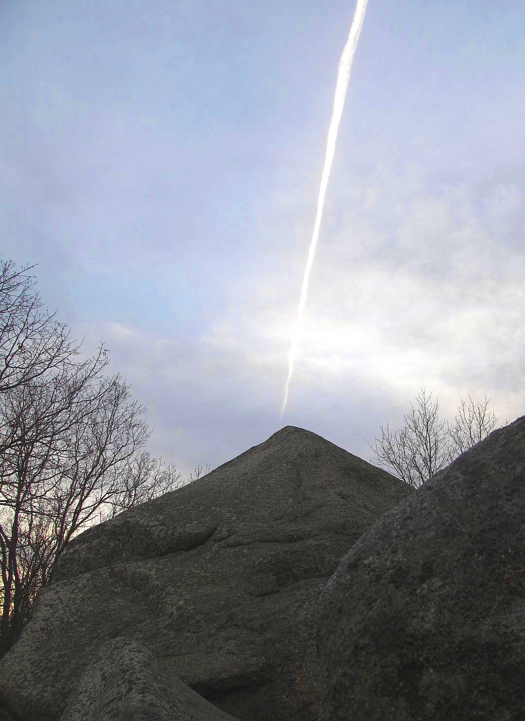
Our afternoon hike was to Whale's Jaw. Whale's Jaw used to resemble it's name much more than it does now. Not long ago the 'jaw' portion split off and fell. Some claim it was due to a fire being set beneath it. I find it rather hard to believe that a smallish fire would break such a large boulder (about 18 - 20 feet at the tallest point). My thinking leans more towards the hundreds of years of water freezing and thawing in the 'jaw' joint.
 |
| the 'jaw' that fell off is to the left |
Since it was getting on toward sunset, it was a quick trip of about 45 minutes.
 |
| The jaw 'vapors'! |
We'll head out (or In) past Whale's Jaw again soon.
On our third venture to Dogtown we followed Dogtown Road and saw some of the cellar holes. From there we hiked the Boulder Trail and captured fourteen more Babson Boulders. Only six left to find! And for those of you doing the math, that little discrepancy will be explained in Cat Lovers in Dogtown - Trip Three
Subscribe to:
Posts (Atom)