'R' and I have decided that our get away from home destination shall be exploring Dogtown.
In 1741, 20% of Gloucester's population lived in what was then known as the Commons Settlement. This area covers the majority of the center of our island and was primarily a farming and forestry based economy. The fishing industry which eventually grew to be the main industry of the island was at that time nearly non-existent due to great losses to piracy. The Commons Settlement was also the hub of the island with roads connecting Gloucester to Lanesville to Annisquam to Rockport. Sixty of the most prominent island families called the Commons Settlement home. It was the most desirable part of town.
The men of the Commons Settlement participated heavily in the Revolutionary War and at the end few remained to return to their homes on the island. Their widows were left to try to eke out an existence on land that had been stripped of all the wood. Many subsisted on the abundant berries found and killed their animals for the last remaining meals of meat. Whether for company or for protection, the women left at the Commons Settlement kept dogs. That, combined with the rapid decay of the area, seems to be why the Commons Settlement, once a thriving, desirable community became known as Dogtown.
With the end of the war and control gained over the local waters, the fishing industry grew. Prominent families wanted to live in new, elegant homes at the harbor. New roads were built that, in staying along the water, bypassed Dogtown.
In 1830, suffering from frozen feet, the last resident was removed from the cellar of a home and placed in the Poor House where he died within a few days. By 1841, there were only six of the original 80 houses left in Dogtown. In 1845 the last house was torn down. Dogtown was an embarrassment.
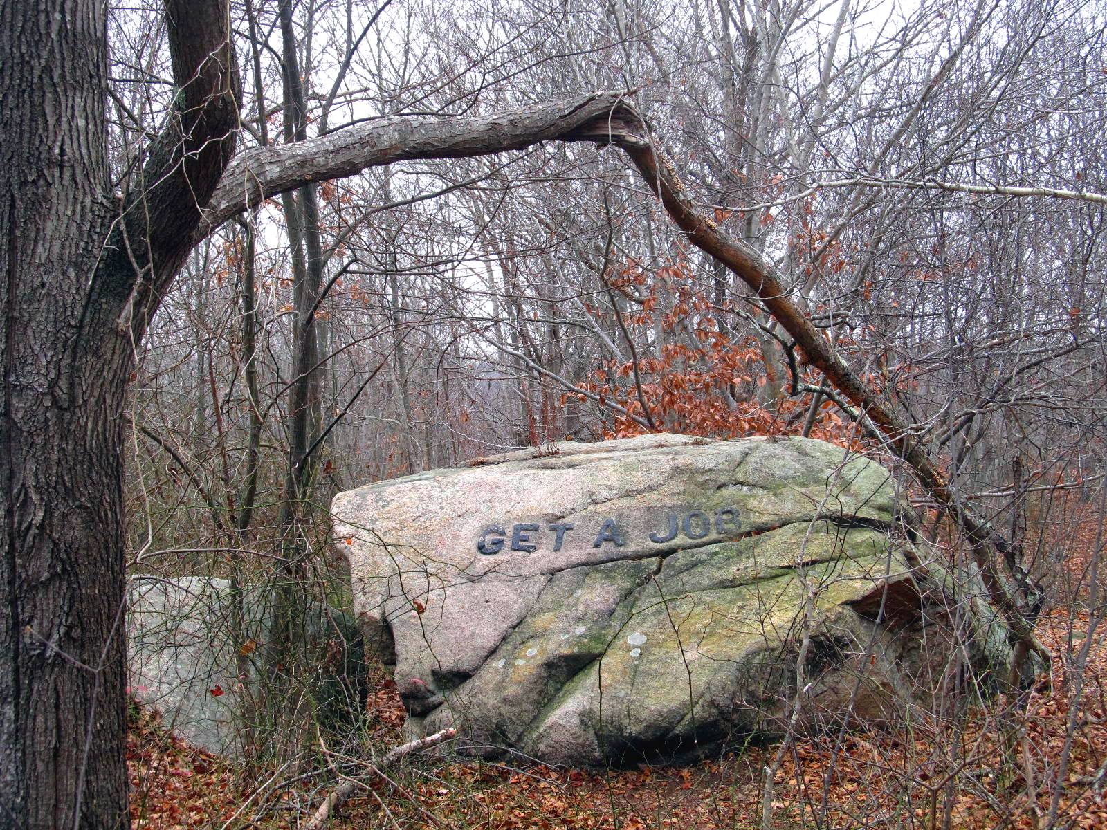
The land was left vacant. Eventually Roger Babson purchased a large portion with the intent of keeping open space on the island. In the years that followed, he not only donated a large portion to the city for a reservoir, he also hired out of work quarrymen to 'write' a book of morals by carving words in some of the large boulders of Dogtown. The acreage of Dogtown is a vast expanse of terminal moraine. Large granite boulders called erratics are strewn about the area and acres are covered in piles of granite 'rubble' left behind when the last great ice flow receded.
 |
| Trees have grown between the boulders in the terminal moraine |
Present day Dogtown is filled with a maze of trails running between the old Dogtown Road, the Commons Road, and the Old Rockport Road (don't let the word road fool you...they aren't paved!). Along the trails are markers indicating the 'cellar holes' and other bits of interesting things like Granny Day's Swamp. The casual hiker can easily get lost and 'R' and I were sure to bring several maps (even if they were a bit conflicting between themselves) and a cell phone. We decided to explore with a definite plan and to keep track of the time at certain locations. We always mark any turns taken from the main trail. We are determined NOT to dial 911 as a tourist did recently!
 |
| Old Rockport Road |
Our first venture In was from Old Rockport Road. Not much to be seen along there! It would have been far more productive to have entered from near Blackburn Circle (Blackburn Industrial Park) where it would have been a short wooded walk to see: The Babson Boulders!
and

and


Our first five Babson Boulders. Only 19 left to find!
At that point it was getting chilly and foggy (and darn close to lunch time) so we headed back by the same route as we went in. We decided to try a different hike in the afternoon.
Our afternoon hike was to Whale's Jaw. Whale's Jaw used to resemble it's name much more than it does now. Not long ago the 'jaw' portion split off and fell. Some claim it was due to a fire being set beneath it. I find it rather hard to believe that a smallish fire would break such a large boulder (about 18 - 20 feet at the tallest point). My thinking leans more towards the hundreds of years of water freezing and thawing in the 'jaw' joint.
 |
| the 'jaw' that fell off is to the left |
Since it was getting on toward sunset, it was a quick trip of about 45 minutes.
 |
| The jaw 'vapors'! |
We'll head out (or In) past Whale's Jaw again soon.
On our third venture to Dogtown we followed Dogtown Road and saw some of the cellar holes. From there we hiked the Boulder Trail and captured fourteen more Babson Boulders. Only six left to find! And for those of you doing the math, that little discrepancy will be explained in Cat Lovers in Dogtown - Trip Three
1 comment:
wow those are beautiful pictures! very interesting! come check out my blog at talesofasinglehousewife.blogspot.com
Post a Comment